World over, I’ve observed some ingenious transport plans implemented, particularly in the public transport realm.
While we are operating the world’s largest Tram network and have vast investment into our heavy rail network underway, is the world’s third most liveable city really pulling its weight in planning a multi-modal city?
After arriving in Panama City, my wife and I had a chance to take our first rail-based Public Transport (PT) on the trip and were pleased to discover that on a single transport card, we were both able to travel around the city metro with ease. More cities would follow with Medellin, Colombia; Lisbon, Portugal; and New York, USA offering us the opportunity to travel using a single travel card.
Lisbon also demonstrated masterful management of tourists in the form of a tourist travel card that directed visitors to all forms of city public transport and the key trainline to/from Sintra. This convenient form of public transport was paid upfront and ensured tourists would assist in the operations of the city fleet without becoming a burden on the network.
Melbournians regard transfers ‒ the act of moving between one rail line to a tram, bus or another rail line ‒ with frustration, but are the standard approach to getting around a city in the northern hemisphere. Istanbul’s extensive network of underground metros never ran through the same station. Yet, the extension project to connect the city’s second airport in the east, requiring transferring through different ticket gates, shows how effective a transfer between each line can be (and ensure patronage/fare capture is made).
The Netherlands was also a standout for utilising short-run trains within their nationwide network to access smaller towns without impeding journey planning. More so, bus interchanges and bicycle storage would directly align with the rail network to ensure a “cover all” capture of living outside the bigger cities.
Back home, with our heavy infrastructure changes continuing to evolve the network, one can easily forget how established the central wheel and spoke network for heavy rail is in Melbourne City. With the Metro Tunnel soon to be completed, the capacity in the network is beginning to be planned. But options are not locked in for the order of upgrades and how these flow into land use planning.
We have an arrangement where networks head back into Melbourne regularly, but operation frequency is much lower between each regional city.
To catch up to the global precedent, Victoria can start planning for the integration of transport in our state capital to create an interconnected and future-proofed transport network for the urban heart of the state. The Transport Integration Act of 2010 stands as the key benchmark in addressing this target.
As budget travellers, walking around each location was the best way for my wife and I to save a dollar, while also getting a feel for the urban spaces we were visiting and how residents experience their street network.
Throughout the trip, a few exceptional cities for pedestrian experiences were:
• Breukelen, the Netherlands
• New York, USA
• Bogota, Colombia
• Skhoder, Albania
• Hanoi, Vietnam
These locations stood out for a few collective reasons. All had some form of pedestrian priority, particularly where vehicular or cycling traffic was combined in the same space. All had streets closed for pedestrian-only access. All had active frontages to create multi-trip destinations for pedestrians. Only Hanoi is distinct from the group as having more standard car congestion through the roads in the centre of the city. Yet, speeds were low and were easy to navigate (from our local experience).
On the other end of the spectrum, we encountered poor walking experiences in cities which were non-conducive to travellers, such as:
• Mumbai, India
• New York, USA
• Ho Chi Minh, Vietnam
• San Salvador, El Salvador
• Tirana, Albania
These locations were less inviting because all had areas on the edges of streets that were degraded, full of infrastructure for buildings/vehicles, didn’t prioritise pedestrians or weren’t enforced for pedestrian access. Trying to walk around these locations would often result in navigating onto the road (or the road traffic on the footpaths). Footpaths existed; they just had other uses that took priority.
Mumbai makes the above list because transport in the urban centre focused on moving vehicles (particularly rickshaws), with pathways and crossings more of a hindrance to vehicles than a network for pedestrians.
New York has a place on both lists since there is a priority between where investment is occurring in the city and where gaps exist.
Hanoi and Skhoder were easier cities to navigate on foot. Yet the larger centres of Ho Chi Minh City and Tirana were harder spaces to navigate, particularly with larger blocks outside the centre of the city and high demand for space outside of commercial premises.
While these are just snapshots of some neighbourhoods experienced in the city, tourist areas tend to attract larger pedestrian volumes and, therefore, the experience of pedestrians is key to keeping tourist dollars in the city.
So, what makes people choose to walk? At the core of any good walking experience is the footpath network you strut on. Pedestrians typically seek paths that are: direct, comfortable, engaging and safe. But are we building path networks that meet these requirements?
The exceptional cities had a few things going for them. Where paths were shared, pedestrians were clearly prioritised and other road users were respectful. Where- the paths were separate, the infrastructure was of a high standard and pedestrian pathways clearly delineated and supported movement (so not congested / used for other purposes / no choke points etc.)
The pandemic showed us that some of our footpath infrastructure is lacking, but we get away with it because often we decide not to walk. So where can we take Melbourne to follow in the footsteps of the good examples and avoid replicating large centres with poor-performing pathways?
Firstly, it’s targeting quick wins in footpath networks. That’s ensuring pram ramps exist at intersections. It’s having a look at the “Goat Tracks” between footpath networks to see where pedestrian desire lines are and filling in the spaces. It’s also providing connectivity and support at Bus Stops for completing the pedestrian links between Public Transport journeys and destinations.
Secondly, it’s important to separate of cyclists and pedestrians in urban areas. Growth areas are demonstrating promising planning with bicycle paths along main road networks, supported by Shared User Paths and offroad pathways for lower traffic roads. Where the existing urban areas should begin to follow is in the provision of space for bicycles in appropriate areas for network links. Not every road should be for bikes and not every street should be for parking.
With opportunities to live a little more locally through our volunteering stints and time with friends, there is a chance to understand the mechanics of different environments. So, what am I bringing back into the office with me for 2023 and onwards?
Firstly, to stop focusing on the picture in front of me and start thinking about how these puzzle pieces fit into the greater picture. Every project has its boundaries and limits of work, but they shouldn’t be roadblocks to progressing network improvements, particularly for cyclists and pedestrians.
Secondly, some of the policy shifts we talk so deeply about for the future of Melbourne are already up and running successfully, without coordinated planning input. The benefits of our systems are numerous, but they also can hinder how we improve urban environments. The X-Minute City is a fantastic example of this.
Thirdly, there is power in people streets. We have seen a great example of this with Brunswick East Primary School’s Shared Space Street. Cars are more agile than we think, particularly, when given street signage and direction to navigate a space so, we can find ways to creatively support pedestrianised spaces.
The transition in our industry times perfectly to bring these observations to the forefront of development. If we are going to create liveable centres, we need to learn from those who have already been bold and not maintain the status quo.
Ben Thomson is a Senior Transport Engineer with over 8 years of industry experience in infrastructure delivery and planning. Feel free to reach out to discuss these and other insights from abroad here bent@ratio.com.au
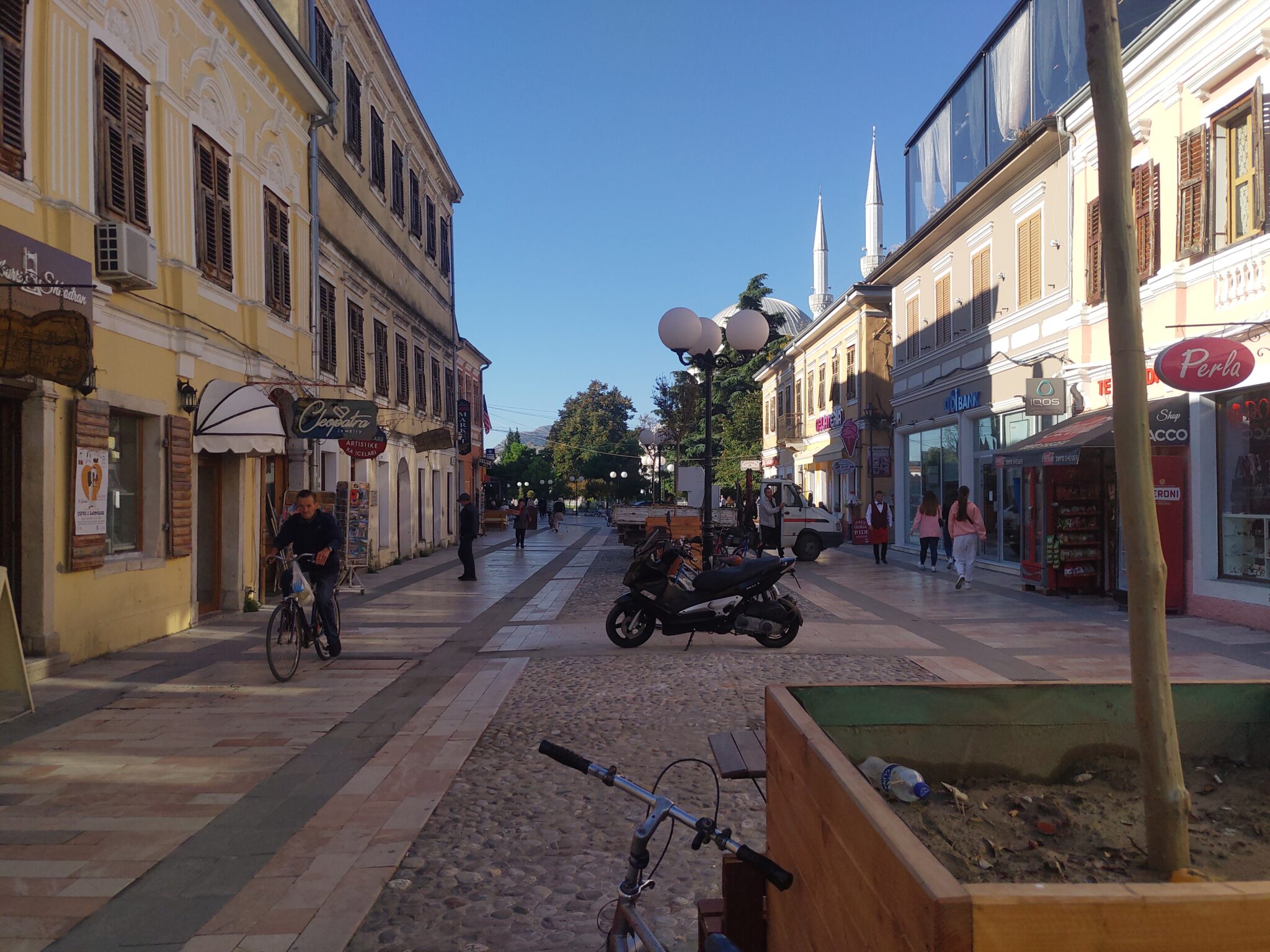
Ruga Kole Idromeno, Shkoder, Albania
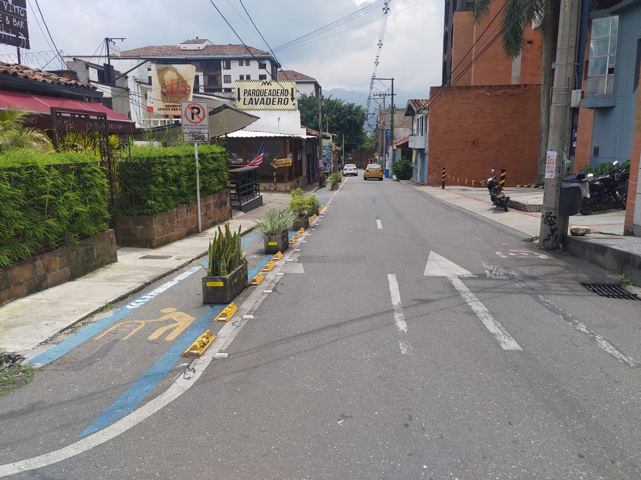
Calle 9, El Poblado, Medellin, Colombia
Monteverde-La Fortuna Shortcut, Guanacaste Province, Costa Rica
Avenida 16 de Julio, La Paz, Bolivia